Summary
Şebinkarahisar; It is a district located in the interior of the Eastern Black Sea Region of Giresun province. Şebinkarahisar; It is a district in the eastern Black Sea region of Giresun province of Turkey. Şebinkarahisar was a liva during the Ottoman Empire. In the Republican Period, it was converted into a province (province) until 1933 and into a district in 1933 and connected to Giresun province.
Historic
The city’s first historical establishment location is the village of Isola (now Güneygören). The city of Isola, which until the Romans was the most important settlement of this region, began to lose its importance from the Romans. Nikopolis (Nicopolis), founded by Pompesyüs (Pompey), one of the Roman Commanders who abolished the Kingdom of Pontus, on the site of today’s Bayramköy village, has grown and become the center of the most important settlements of the region. In 395 A.D., when the Roman Empire was doubled, Anatolia became part of the Byzantine Empire, and the city of Nikopolis (Nicopolis) was renamed Mavrakastoron (in the sense of Black Castle).
Theodosius (Teodos), the Roman Emperor in the late 19th century AD, recently came from Central Asia, and the Peçenek and Kuman Turks came to the interior of Anatolia and seized Middle Eastern Anatolia for a while. This region, which was named Elgün or Keygun at the time of the Turks, becoming a Kögonya when the Romans got their hands on it again, the word Keygun becoming Kögonya (Köğonya) and its name was mentioned as such.
After Anatolia becoming in the hands of turks, the city of Şebinkarahisar was renamed Keygune for many years, and the name of the city becoming Karahisar in accordance with the castle of the city. In 1473, he stopped by Şebinkarahisar on his way back to Istanbul after the Battle of Otlukbeli of Fatih Sultan Mehmet Han and named this city Karahisar-ı Sharki, where he stayed for three days. It is also the place where Suleiman I, The Kanuni Sultan Suleiman, was the first starboard principality, that is, he was governor. In 1508, he was appointed as the starboard man of Şarkikarahisar.
Until 1924, the name of the city remained Karahisar-ı Sarki, Mustafa Kemal ATATÜRK, who came to Şebinkarahisar on October 11, 1924, changed the name of the district to Şebinkarahisar during these visits. His name is Şebinkarahisar now.
Şebinkarahisar was ruled as a principality during a period of 410 years from 1075 to 1473, when it was in the hands of Turks.
Şebinkarahisar district remained connected to Amasya province from 1478 to 1515 when it joined the territory of the Ottoman Empire. Şebinkarahisar, which remained connected to Erzincan province until 1538, was taken from Erzincan on this date and connected to Amasya province again. At the same time, the current Giresun district, Ordu provincial and Gölköy district were also connected to the Şebinkarahisar Banner. In 1865, Şebinkarahisar was taken from Trabzon province and connected to Sivas province together with Amasya and Tokat.

Şebinkarahisar remained a banner in Sivas until 1923, when it was made a province.
Şebinkarahisar has sadly survived many fires in its history. During the 1st World War, indigenous Greeks and Armenians rioted, the city was destroyed and burned down by the Armenian Revolt of 1915, and many old structures were destroyed. The traces of history have been erased. After the liberation war was won, it was decided to make livas a province in 1923, and as a result of this decision, Şebinkarahisar, which was liva in those days, was also made a province. However, in 1933, the revenues were brought to the district state on the grounds that they did not cover their expenses and connected to Giresun province. It’s just the result. As can be seen in the Archives and researches of the Prime Minister’s Office, the investigative author Murat Dursun Tosun; For nearly 30 years until 1933, when the province was taken, the managers (the mayor at that time, it was reached in 1933 due to the squandering of money coming in, the lack of single service, as well as the complete destruction of many earthquakes, the burning of most of the city in many major fires, the burning of the city in Armenian events, the grounding of trade, the great migrations, and the city was now run out of waste, its coffers were empty, and according to many provinces, municipalism and many issues were.
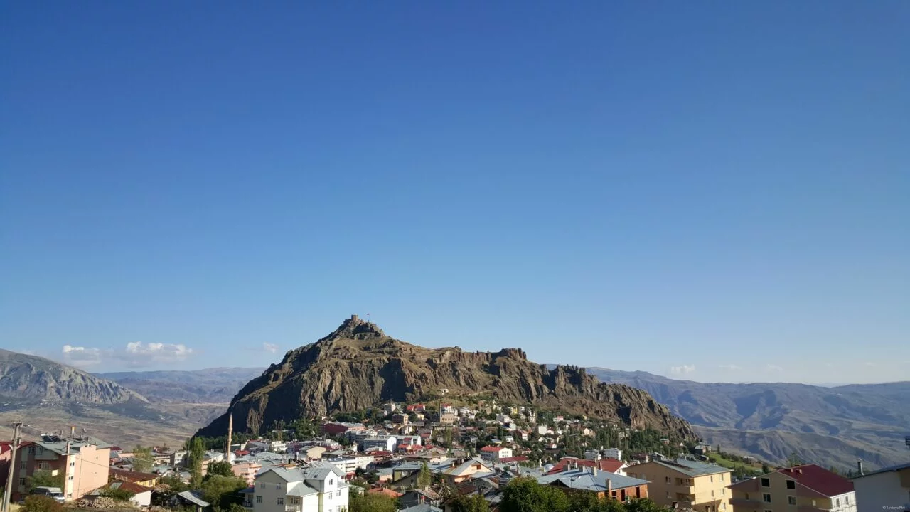
Şebinkarahisar Castle, one of the most important symbols of Şebinkarahisar, rises on a basalt hill called Hacıkayası in the south and southeast direction of the district. The castle is located at an altitude of 250-450 meters from the ground on which it sits. The western direction of the castle is relatively more conducive to the exit, while the other aspects are the abyss. There are up to seventy houses in the western and southern part of the outer castle inner castle until the early 21st century. In the 1915 Armenian revolt and the times after that, houses and mosques were completely destroyed. Thousands of years of city has lost that texture due to fires, earthquakes, Armenian rebellion, etc. After the 1920s, treasure hunters dug all over the castle and riddled the castle with holes.
The inner castle, called the tower, consists of high walls and walls. There is a three-story palace and a dungeon carved into a rock. The only way to enter the outer castle is with two doors, the entrance to the inner castle is provided by one door. Cisterns are located in almost every direction of the outer castle. As can be understood from the examinations and architectural style, the castle was built by the Romans. According to the information obtained, the castle during the wars between The Byzantines and arabs and Selçuklular later ought as a refuge for the local people in the wars between the Anatolian Principals themselves. There’s not much left of the walls yet. The rest of them were spray-painted all over by traitors and history.


Social and Economic Structure
According to the last census conducted in 2019, the total population of Şebinkarahisar was 20,459. In history, the Principality of Mengüçlü (Mengücekli) has been an important center in principalitys such as the Principality of Eretna (Eretna State). Şebinkarahisar was renamed Keygune for many years after Anatolia beed in the hands of Turks. The name of the city has become Karahisar in accordance with its castle.

Kelkit Valley has an impact on social life in terms of geographical structure, land and settlements. Şebinkarahisar, which is usually dominated by mass settlement and agricultural-animal husbandry life, is different in this aspect compared to Giresun. It has more of the characteristics and social order of Northeastern Central Anatolia. It is largely similar. Şebinkarahisar, which has a transportation problem with the provincial center, has not gained the expected economic vitality over the years. Although the district has 41,185 hectares of plantable agricultural land, only 21,000 hectares of it can be used. The city has made huge migrations over the years.
County Us Founded in 1999 Şebinkarahisar Vocational School in the intervening 19 years during Turkey’s entered the most part with between vocational schools, our district also increased more vitality along with that of around 2,000 college students, but especially from 2014-2015 years after the establishment of a high school profession in many countries Then there was a big decrease in the number of students.
The building, which was also built by philanthropic businessman Feyzi KIRAÇ in our district, has been operating as a School of Applied Sciences since 2010.
Kılıçkaya Dam, which is located within the boundaries of the district, contributes significantly to the economic development with fishing. Another economic activity in the region is beekeeping. In the district, the milk factory, up to 20 companies and about 400 tradesmen, large and small, are engaged in commercial activity. In addition, the old mining tradition continues and lead and zinc mines are mined around Mount Tutak. In addition, according to MTA data, it is stated that there are rich uranium and gold reserves in Şebinkarahisar. In recent years, modern mulberry products pestil-molasses ember plants have also been established. In bağlar neighborhoods, a large part of the population receives income from the sale of mulberry products. Walnut farming has gained importance in recent years and walnut cultivation has gained importance with the name of “şebin walnut” in the region where the best walnuts of the country grow. Due to global warming and climate changes/imbalances, the warm winter months in recent years have resulted from a lack of snowfall; with the early opening of the leaves of walnuts, mulberries and other fruit trees, tree colds have increased with frost formed in the spring months, as well as a large decrease in the average annual rainfall (Highest drought in 2014) and resulting agricultural droughts when meteorological data are examined in recent years; has reduced the product recollection. Another source in terms of economic activities is livestock.


Culture and Tourism
Şebinkarahisar district, where the names of Kınık, Çepni, Çavdur, Kargun and Salur, which is one of the old Oğuz Turkmen sizes, is one of the important places where Turkish culture and values live. Behramşah Mosque in Avutmuş Neighborhood (construction year 1185, is one of the oldest historical mosques of our country) in Giresun pregnited state and one of the oldest historical mosques of our country) while the Taşhanlar at the entrance of Şebinkarahisar Castle and fatih mosque standing right opposite show that the Ottoman Empire had a say in this region. On the other hand, it is possible to add more to the family of these important works, which are expressions of both tourism and cultural existences. Şebinkarahisar Castle, Tamzara Mosque, Kurşunlu Mosque, Kadıoğlu Mosque, Taş Masjid, Topal Mehmet Paşa Bath, Avutmuş Bath, Tamzara Bath, Kurşunlu Fountain, Zeynube Hatun Fountain, Eyvan Fountain, Muftü Efendi Fountain, Hüseyin Efendi Fountain, Hacı Yakup Fountain, Alay Fountain, Suleymanağa Fountain, Pertevniyal Fountain and Pertevniyal Museum and Ataturk Museum is one of the most important historical monuments. The richness of the National Cultural assets in Şebinkarahisar, the richness of cultural life. In these places, following a path from Selçuklu to Ottomans(Osmanlı) and from there to Republic Turkey tells us about the cultural flow direction experienced.
On the other hand, Şebinkarahisar district, which has cherished other Christian communities besides Turks in the past, also has traces of the characteristics of this period. Licese Church, Taşhan Church, Asarcık Church and Meryemana Monastery are historical places to visit in terms of tourism.

Şebinkarahisar Castle


The construction date of Şebinkarahisar Castle is not known, but it is thought to have been built in the Hellenistic Period, i.e. in antiqui times. The castle, which came under the rule of the Persian Empire in 550 BC, is a historical castle with a magnificent view that sees all over the hill. Today, 90% of the walls are devastated by disreiring, burning and earthquakes.
ATATÜRK House and Museum

Mustafa Kemal Atatürk’s one-night stay during his visits to Şebinkarahisar on October 11, 1924, and the house belonging to Tüfekçizade Mustafa Ertem was restored and turned into a museum. The house, which has a traditional building feature of Şebinkarahisar, has two floors. Local building material was used. There are many works and photographs from that period. Entry is free of charge. This historic building was exorcesed by the Treasury and restored by the General Directorate of Highways with a spend of TL 3 million within the framework of the “100th Anniversary Celebration” program. With the works carried out in 1982, it was opened as a museum on October 11, 1982, on the 58th anniversary of Atatürk’s arrival in the district. It’s still active.
Fatih Mosque

It was started by Fatih Sultan Mehmet on August 29, 1473, after winning the Battle of Otlukbeli, and was completed in 5 years. The mosque has been burned twice. In 1888, it was brought to its present form with the leadership of Mutasarrıf Rasip Paşa and Defterdar Mahmut Nedim.
Fahreddin Behramşah Mosque

The mosque, located in the Avutmuş neighborhood of our district, was built in the XII century by his son Muzafferüddin Mehmet on behalf of Fahreddin Behramşah, ruler of Mengücek. In addition, another feature of this mosque is that it is the oldest mosque in Giresun as of the year of construction (1184), it is the first work of Turks in the Black Sea, and it is also one of the first works of the Selçuklu State in the Black Sea region. The last major repair/restoration was carried out in 2017 and opened for worship.
Taşhanlar

It was built in the XVIIth century by Şebinkarahisar Sipahi Chief Taban Ahmet Ağa. These buildings, which were built from kagir bedes on the left and right of the road leading to the castle and the middle neighborhood, remained intact until the 1939 earthquake. The bedestens, which were used as prison from 1915 to 1939, were partially destroyed by humans, causing the earthquake and the remaining stones, iron and bullets.
a repair tender was made by the General Directorate of Foundations on 14/12/2017 at a cost of TL 5 Million with the initiatives of the Provincial Administrators, this historical monument will regain its former appearance.
Istiklal Fountain

The fountain, located opposite the old town hall of Şebinkarahisar, was later brought to the Republic Square. A wooden monoblock cylinder carried by four stone milks is made of one stone. Cesme was built in 1927 by Mayor Hüsnü Bey in memory of the Turkish War of Independence and the establishment of the Republic.
Licese Church
It is connected to Şaplıca Village and 11 km from the District Center. Built in 1874, the church is located in licese district. He’s already devastated.
St. Mary Monastery (Meryemana)

Made around A.D. II YY, 11 km from the district center. Sarıyer Village is located in kayadibi neighborhood. It is carved into a shattered rock as a structure. It has four floors and the fourth floor is the church. On the first three floors there are 32 rooms suitable for various services. In recent years, restoration works have been carried out in the St. Mary Monastery and its path and it has regained its former appearance.
Geography
Physical Properties
Şebinkarahisar is located between Kelkit Region and Giresun Mountains in the Eastern Black Sea region of Northern Anatolia and the altitude of the center of the city is 1374m. The average altitude is between 900-1515 meters when considered as neighborhoods connected to the center and center. In general, the lowest altitude area increases to 825m around the dam and the highest to 3100 meters on Karagöl mountain. There are 1618 Km2 area and 1480 elevation Alucra district to the east, Dereli district with an area of 820 Km2 and an altitude of 50 meters to the north, Suşehri district with an area of 1665 Km2 and an altitude of 1050 meters to the south, and Koyulhisar districts with an altitude of 968 km2. The area of the district is 1382 km2 district center altitude is 1374 mt. Geographical relam and longi what is going on: 40 28 North, Longi by: 038 42 East.
Climate
Alcause Şebinkarahisar is located in the Eastern Black Sea Region, central Anatolia climate has similar qualities in terms of climate. It is the climate experienced in the places in the lane from Bolu to Şebinkarahisar, which is called the transitional climate (Black Sea after climate). Summers are hot and dry, winters are cold and snowy. The most precipitation is falling in the fall. (most of the precipitation that has changed in the average of recent years is at the end of the spring months) High mountains running parallel to the coastline prevent it from passing inland, keeping damsy and abundant rainy winds from the sea. Therefore, the average rainfall exceeds 1500mm on the coastline, but falls to 500-700 mm inland. The average annual rainfall in recent years is 550-600mm.
Vegetation

Of the 1382 km2 area of our Şebinkarahisar district, 24% with 35,568 hectares of field land, 24% with 3295 hectares of vineyard-orchard land, 1% with vegetable lands with 1054 hectares, 2.8% with 3954 hectares of meadow land, 15.8% with 21,747 hectares. pastures and plateaus constitute 4.8% shrub lands with 6590 hectares, forest land with 9,385 hectares and 7.1%, and 42.1% unused lands with 55,680 hectares. (This information will be updated soon)
Streams
The Avutmuş River flows from the Eğribel ridges and Asarcık Plateau and flows into the City water in the Arzuman locality. Its length is 20 km. The City Water emerges from the Karabörk ridges of the Alucra district and after merging with the Manastır water, it mixes with the Kelkit River next to the Tönük Village. Its length in our district is 40 km. Darabul water emerges from Sarıçiçek Plateau, passes through narrow valleys and joins the Kelkit River across the village of Güvercinlik. Its length is 20 km. The roof water comes out of the foothills of the Karagöl mountains, passes through the narrow and Derin valleys and joins the Kelkit River. Kelkit River; The Kelkit River, which enters the boundaries of the district within the borders of Ocaktasi and Kayalı Villages, flows from east to west. Its length within the borders of our district is 40 km and there are four bridges on it.
Transportation
Şebinkarahisar district has difficulties in transportation with other centers due to its climate and land structure, especially in winter. In the intense winter conditions, especially the closing of the 2200-altitude Eğribel pass, which provides contact with Giresun, prevents transportation due to snow and icing from time to time. (Update: As of 2015, the curvature tunnel works have started, the tunnel is planned to be opened for transportation around 2023, with this tunnel, the transportation to the city center will be shorter and the most challenging part in the winter months will be overcome) (Update: As of December 28, 2021, the only tube of our curvature tunnel has been opened, transportation is now provided from here. Update: As of November 1, 2023, the double tube tunneled crossing is operational in both directions.) Şebinkarahisar, 118 km., with the provincial center. (108km after tunnel opening) 50 km with Alucra district, About 55 km with Sivas-Suşehri district. is located within a distance. Bus services to Giresun, Sivas, Istanbul, Ankara and Antalya are available daily. The nearest airports are in the provincial center of Giresun and the center of Sivas. Ordu – 130km (avg. 2 hours 18min), 203 km to Sivas Nuri Demirağ Airport (avg. 2 hours 51min).
